It took me a while to get over the shock of all the police and the fact that the G8 Summit is going to be right there in that tiny little town. In guidebooks, the town is spelled as “Toya-ko Onsen”, so I didn’t recognize it as “Toyako” on all the signs at the airport. I simply didn’t realize I was going to the exact location of the Summit. But there I was, surrounded by police. I didn’t want to draw any extra attention to myself, so I refrained from taking photos of all the police activity. Sorry!
Once I recovered from the initial shock (and asked one of the many police officers for directions), I headed to the excellent Volcano Science Museum which explained the geology of the area. Toya-ko is actually a caldera lake. The original caldera was created 110,000 years ago, but along the crater rim now are active volcanoes which have erupted very recently – in 1977 and in 2000. In fact, Mt Usu is one of the most active volcanoes in Japan and is very predictable, erupting every 20 to 50 years! Luckily, before it erupts, there are very consistent earthquakes which warn the town to evacuate. The museum had a great movie (with an audio headset in English for me). It was really well done, except for when they referred to the volcano as “this tender mountain”. The museum also had a simulation room where they played video clips of the last eruption, and the floor rumbled and shook. I spent a lot of time in this museum!
After the museum, I had planned to take a cable car up to the rim of Mt Usu and do some hiking up there, but I was very disappointed to learn that the cable car was closed for maintenance – due to open in time for the G8 Summit, of course. The pictures from the base of the volcano don’t do it justice, but you can see the steam from the vents.

Right near Mt Usu is Showa-Shinzan. Its name means “new mountain from the Showa era”. Back in 1943, it was a wheat field; then a series of violent earthquakes in December 1943 raised the land on one side and created a parasitic volcano. Because it was during WWII, the new volcano’s sudden appearance was kept secret, but the local postmaster kept records of the volcano’s growth over the next two years, providing valuable information for volcanologists.


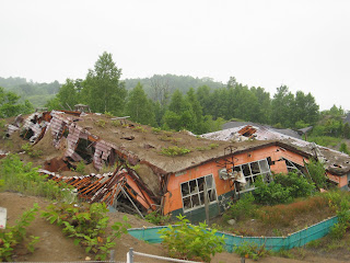
I went next to the Nishiyama Crater Trail which was a boardwalk through the destroyed roads, cars, and homes from the earthquakes and mudflows associated with the volcanic eruption in 2000.


My last site for the day was the Konpira Crater - Remains of the Disaster Walking Trail. As its name implies, it also was a walk among destroyed buildings. These buildings were destroyed by hot mudflows. There were sediment control dams (dark brown structure) and canals, some of which were already in place and operational for the 2000 mudflows. Several buildings were left – an apartment building whose first floor is nearly buried in mud and a public building (signs were confusing whether it was a school or public bathing house). There was also a bridge which had been washed down stream and finally landed here.


After a full day of sightseeing, I soaked my feet in a public foot onsen (hot bath) on the lake shore before catching a bus back to Muroran for the night.
Stay tuned; more to come!

No comments:
Post a Comment